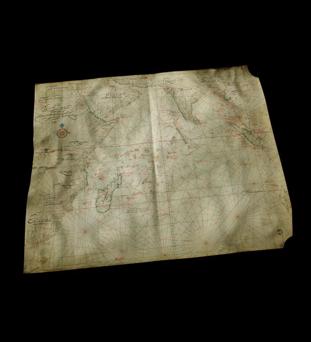
Blaeu’s East India Company map
This maritime chart by the master cartographer Joan Blaeu is part of the Corpus Christi Collection, a collection of Dutch East India Company charts that lay hidden in England for three hundred years and now belongs to the Maritime Museum in 2006 after being purchased for millions.
This map could be used for plotting courses across the oceans
Joan Blaeu produced this hand-drawn nautical chart of the Indian Ocean in 1669. It shows Africa on the left, Arabia at the top and parts of Malaysia and the Indonesian archipelago on the right. It is what is known as an ‘overzeiler’ – an ‘across-sailer’ – that allowed courses to be plotted across the oceans. Until the seventeenth century, ships preferred to stick to the coastlines to avoid getting lost. That was a safe but pretty inefficient way of sailing and ’overzeilers’ offered a faster alternative for those who dared to leave the coasts. The trick was to sail east-southeast from the Cape of Good Hope to the small island of Sa Paulo and then head for the Sunda Strait from there with the westerly wind in your sails. Anyone who missed Sa Paulo and sailed too far east ran the risk of ending up on the reefs and rocks of the Australian coast. One nice detail is the place names inscribed in black along the coast. The names of the bodies of water are in red. Unknown smaller islands were often given names that were invented by the passing skipper. When a cartographer adopted these names – followed by his fellow mapmakers – they became widely accepted. Internationally too: Australia went by the name Nova Hollandia (or New Holland) until deep in the nineteenth century, including in France and England, and Tasmania (named after Abel Tasman) got its name similarly.
The East India Company’s master cartographer
Blaeu was a publisher and printer as well as a cartographer. This hand-drawn chart of the Indian Ocean is an example of high-quality Dutch cartography in the seventeenth century. Maps like these were copied and served as examples for printed charts. It has been drawn to scale and neatly finished, with a compass rose added. On board, maps like these were kept rolled up in tin tubes. The seam in the middle of the chart is therefore from a later date. The curves at two of the corners tell us that the parchment came from a calfskin: those are where the legs were. One advantage of parchment over paper was that it was much more resistant to the conditions, even in tropical climes. Because the chart is hand-drawn, it is a unique item, signed with the name Joan Blaeu. The Maritime Museum owns a quarter of the world’s surviving hand-drawn maps by Blaeu.